Severe weather will be possible this holiday weekend…
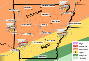
Isolated severe thunderstorms will be possible late Saturday afternoon and early evening across the northern/northwestern half of Arkansas. While uncertainty exists on whether storms can form and become mature, any storm that does form will have the potential to produce very large hail and damaging winds. These storms may also be capable of producing a tornado or two.
As time goes on late Saturday evening into the early morning hours on Sunday, the potential for seeing more organized thunderstorms will increase as a cold front drops south towards the state. These thunderstorms could also become severe, with damaging winds possible with the strongest storms, as this activity looks to form into a larger, more organized line or complex. Large hail and a few brief tornadoes will also be possible as this line or complex moves south across northern Arkansas. Some locally heavy rain may also be seen, resulting in an isolated flash flood threat. Folks near flash flood prone areas will need to be aware of this possibility.
By the daylight hours Sunday morning, the threat for seeing severe weather will have decreased, but the cold front will still be dropping south across the state. Additional thunderstorms will be possible Sunday afternoon and evening across the southern/southeastern half of the state as the cold front pushes through this region of Arkansas. Additional strong to severe thunderstorms may again be possible during this period. Damaging winds and large hail will be the primary threats, along with locally heavy rainfall.
Expect the chances for thunderstorms to decrease by Monday afternoon as the cold front drops south of the state. Drier and calmer conditions will then be seen.


