UPDATE 08/30/2017 8:00AM
- RADAR
- PATH
- RAINFALL
According to the National Weather Service in Little Rock, the remnants of Tropical Storm Harvey were finally moving away from Texas Wednesday morning. Harvey made landfall in southwest Louisiana, and was headed slowly to the northeast. As Harvey approaches Arkansas, rain will become widespread across the southeast half of the state through Wednesday night.
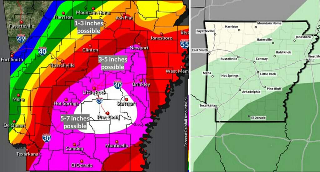
Two to three inches of rain and localized flash flooding will be possible across the far southeast. This includes areas southeast of Hermitage (Bradley County) to Monticello (Drew County) and DeWitt (Arkansas County).
Rain will continue on Thursday in the southeast before Harvey exits toward the Tennessee Valley. By Friday, drier and calmer conditions will be noted, with the concern for hazardous weather becoming low this weekend into early next week.
John Lewis, Senior Forecaster
National Weather Service
Little Rock, Arkansas
ORIGINAL 08/28/2017 8:42PM

…Harvey Is Expected to Affect Arkansas Later This Week…
According to the National Weather Service in Little Rock, early this evening, Tropical Storm Harvey was located south of Port Arthur, Texas, slowly drifting east-southeast. The storm is expected to make an eventual northeastward turn and make a second landfall on the upper Texas coast tomorrow night or early Wednesday. It is becoming more likely that, once the storm makes a second landfall, it will move northeastward and through Arkansas late this week into early this weekend.
At this point, the National Hurricane Center forecast track brings Harvey’s remnants into southern Arkansas near El Dorado on Thursday afternoon, and out of Arkansas northeast of Jonesboro late Friday.
With the system expected to move across Arkansas, heavy rainfall will become likely, and there will be a risk of tornadoes. I will break down the specific threats below…
Heavy rainfall…
Rain will become likely by Wednesday morning, as the outer bands of Harvey move up into Arkansas. The rain will be heavy at times. Rainfall totals of three to seven inches will be possible along the track of Harvey, particularly in the vicinity of and to the east of the center. Localized totals exceeding seven inches are possible.
With the heavy rainfall expected, flash flooding is likely to occur. This will be especially true in areas that see heavier rain bands repeatedly move over them.
River flooding could become a concern, particularly in the White, Black, Ouachita, and Saline basins, and possibly the lower Arkansas south of Pine Bluff.
Tornadoes…
With the outer bands of Harvey, tornadoes will be possible east of the center. Tornadoes associated with tropical systems tend to be weak and short-lived, and will tend to move with the bands—generally south to north or southeast to northwest. The greatest tornado threat will be on Wednesday afternoon and evening, and Thursday afternoon and evening.
Disclaimer…
Keep in mind that the forecast track of Harvey may change, and likely will change to some degree over the next 24 hours. Any adjustment to the forecast track could shift the expected axis of heavy rainfall. Continue to monitor the latest forecasts, statements and warnings from your National Weather Service offices.
Brian Smith
National Weather Service
Little Rock, Arkansas


