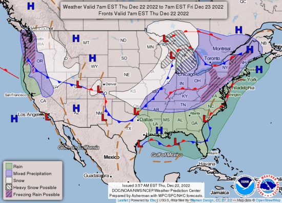
Today is December 22nd, the official first day of Winter, and it showed up ready to work. Arkansas has a hazardous weather outlook, the chance of snow in places, and a wind chill warning. Here’s the forecast according to the National Weather Service in Little Rock:
The Hazardous Weather Outlook is for a Large Part of Arkansas. An Arctic cold front will move across the state on Thursday, ushering in bitterly cold air.
Thursday and Thursday Night
Snow will accompany the front with an inch or two possible across the northern part of the state. A dusting of snow into central Arkansas is possible. Ice accumulations up to a few hundredths of an inch are also possible across northwest and north central Arkansas.
Temperatures will drop very quickly behind the front, possibly as much as 20 to 30 degrees in just a few hours time. Gusty winds will accompany the front, with dangerous wind chills developing. Any water on the ground or on area roads will freeze in a very short amount of time possibly leading to hazardous driving conditions.
The front and any precipitation will exit the state by late afternoon but arctic air will continue to spill into the state. Low temperatures come Friday morning will fall below zero over the north with single digits elsewhere. Wind chill values will drop to below zero statewide and possibly as cold as 25 degrees below zero across the north.
Friday through Wednesday
Cold temperatures and gusty winds will persist on Friday, with highs remaining below freezing statewide. Wind chill values will remain dangerously cold early in the day before the winds start to slacken a bit. Another bitterly cold night is expected Friday night with cold conditions continuing through Christmas day.
A Winter Weather Advisory remains in effect until 9:00 p.m. Thursday evening. A Wind Chill Warning is in effect from 9 a.m. Thursday morning to noon Friday…
What…
Dangerously cold wind chills possible. Wind chills below zero are expected. For the Winter Weather Advisory, the primary potential impact is for the potential of a fairly widespread Flash Freeze. A Flash Freeze occurs when the ground is wet, and the air temperature falls below freezing very fast, resulting in a thin sheet of ice developing along all previously wet surfaces. The ice is typically not very thick, but even a very thin layer of ice is enough to wreck havoc on the roadways.
Where…
Portions of northern, central, and eastern Arkansas.
When…
From Thursday morning through Friday morning… The timing will vary depending on the speed of the cold front. The cold front will move from northwest Arkansas at 8 AM to 9 AM towards Central Arkansas from noon through 2 PM, and through eastern Arkansas from 3 to 5 PM. The flash freeze, if it occurs, will occur approximately 30 to 45 minutes behind the front.
Impacts…
Wind chills could cause frostbite on exposed skin in as little as 30 minutes. Rain showers are expected along and out ahead of the cold front on Thursday. Immediately behind the cold front, air temperatures will drop 20 to 25 degrees in under an hour. Winds will shift from southwesterly to northwesterly and increase dramatically. In the 30 to 45 minutes behind the front, if any roadways remain wet, they will very likely freeze into a thin layer of ice, leaving untreated roadways extremely difficult if not impossible to travel safely.
9 Preparedness Actions…
- Use caution while traveling outside. Wear appropriate clothing, a hat, and gloves.
- Know when the cold front is moving through your area, plan your travel accordingly.
- Do NOT travel behind the cold front if you don’t have to.
- Try to complete shopping before the front arrives to ensure that you can get home safely.
- If you are going to travel, pack a winter weather survival kit in case you slide off the road or are otherwise stranded.
- Pack multiple layers of clothing, pack a few layers of blankets.
- If you have bottled water and ready to eat meals, pack those as well.
- Pack an extra power supply for your phone or other electronic devices.
- If you have a road flare, have that in your vehicle in case you are stranded after sunset so you can flag down help.
- Follow the 4 P’s (see that list below)
A Wind Chill Warning means the combination of very cold air and strong winds will create dangerously low wind chill values. This will result in frost bite and lead to hypothermia or death if precautions are not taken.
Follow the Four P’s… People, Pets, Pipes, and Plants.
- Check on your neighbors, family and friends to make sure they have a plan.
- Bring pets inside.
- Cover your outdoor faucets and let inside faucets drip to prevent pipes from freezing and bursting.
- Cover plants or bring them inside.
EXTENDED DAILY FORECAST:


