RED FLAG WARNING ISSUED UNTIL DECEMBER 11 AT 6:00PM CST
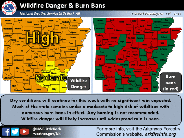
Red Flag Conditions Likely Across Most of the Area Monday… The combination of breezy conditions, very low relative humidity values and low fuel moisture levels will create Red Flag conditions this afternoon. Many areas are also in severe to extreme drought, so even in areas where winds may not get as strong, the low humidity and very dry conditions will still generate dangerous wild fire conditions. Expect some improving wild fire conditions by Monday evening as winds decrease and humidity values increase. However, no rainfall is forecast for the next several days, so a high wild fire danger will persist.
…RED FLAG WARNING IN EFFECT FROM 10 AM THIS MORNING TO 6 PM CST
THIS EVENING FOR BREEZY WINDS…LOW RELATIVE HUMIDITIES…AND LOW
FUEL MOISTURE levels FOR FIRE WEATHER ZONES 003, 004, 005, 006,
007, 012, 013, 014, 015, 016, 021, 022, 023, 024, 025, 030, 031,
032, 033, 034, 037, 038, 039, 040, 041, 042, 043, 044, 045, 046,
047, 052, 053, 054, 055, 056, 057, 062, 063, 064, 065, 066, 067,
068, AND 069…
The National Weather Service in Little Rock has issued a Red Flag Warning, which is in effect from 10 AM Monday morning to 6 PM CST this evening.
* AFFECTED AREA: Fire weather zones 003, 004, 005, 006, 007, 012, 013, 014, 015, 016, 021, 022, 023, 024, 025, 030, 031, 032, 033, 034, 037, 038, 039, 040, 041, 042, 043, 044, 045, 046, 047, 052, 053, 054, 055, 056, 057, 062, 063, 064, 065, 066, 067, 068, and 069.
* WIND: Expect 20 foot winds to increase to over 15 mph by early this afternoon, with some gusts over 20 mph possible.
* HUMIDITY: Expect humidity levels to drop below 25 by this
afternoon, with some areas in the higher terrain of the Ozark
and Ouachita Mountains seeing humidity levels possibly drop below 15%.
Any fires that develop will likely spread rapidly. Outdoor burning is not permitted, since Saline County is already under a Burn Ban.
A Red Flag Warning means that critical fire weather conditions are either occurring now, or will shortly. A combination of strong winds, low relative humidity, and warm temperatures can contribute to extreme fire behavior.
Targt Area: ARKANSAS; BAXTER; BOONE; BRADLEY; CALHOUN; CLARK; CLEBURNE; CLEVELAND; CONWAY; DALLAS; DESHA; DREW; FAULKNER; FULTON; GARLAND; GRANT; HOT SPRING; INDEPENDENCE; IZARD; JACKSON; JEFFERSON; JOHNSON; LINCOLN; LOGAN; LONOKE; MARION; MONROE; MONTGOMERY; NEWTON; OUACHITA; PERRY; PIKE; POLK; POPE; PRAIRIE; PULASKI; SALINE; SCOTT; SEARCY; SHARP; STONE; VAN BUREN; WHITE; WOODRUFF; YELL.


