UPDATE 1:45PM
Flash Flood Warning
THE NATIONAL WEATHER SERVICE IN LITTLE ROCK HAS ISSUED A
* FLASH FLOOD WARNING FOR… NORTHERN LONOKE COUNTY IN CENTRAL ARKANSAS… SOUTHEASTERN SALINE COUNTY IN
CENTRAL ARKANSAS… SOUTHEASTERN PULASKI COUNTY IN CENTRAL ARKANSAS…
* UNTIL 400 PM CDT.
* AT 132 PM CDT, DOPPLER RADAR INDICATED A BAND OF SHOWERS AND ISOLATED THUNDERSTORMS SETTING UP FROM 5
MILES SOUTHEAST OF CABOT TO LITTLE ROCK AND BENTON. THE BAND HAS PRODUCED ONE TO TWO INCHES OF RAIN IN
SOME AREAS ALREADY. GIVEN ADDITIONAL HEAVY DOWNPOURS, FLASH FLOODING IS LIKELY TO OCCUR.
* SOME LOCATIONS THAT WILL EXPERIENCE FLOODING INCLUDE… LITTLE ROCK… NORTH LITTLE ROCK… BENTON…
SHERWOOD… JACKSONVILLE… CABOT… WEST LITTLE ROCK… BRYANT… DOWNTOWN LITTLE ROCK… LONOKE… NORTH LITTLE
ROCK AIRPORT… SOUTHWEST LITTLE ROCK… LITTLE ROCK AFB… HASKELL… SHANNON HILLS… WRIGHTSVILLE… ARGENTA…
TRASKWOOD… TULL… OTTER CREEK…
PRECAUTIONARY/PREPAREDNESS ACTIONS…
TURN AROUND, DON’T DROWN WHEN ENCOUNTERING FLOODED ROADS. MOST FLOOD DEATHS OCCUR IN VEHICLES
Meteorologists with the National Weather Service in Little Rock issued the following statement Friday morning.
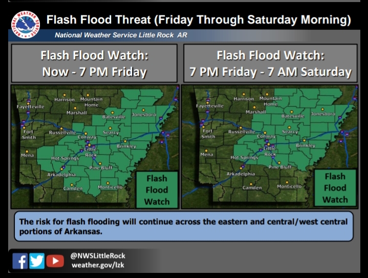
The threat for heavy rainfall will continue today and through the weekend as remnants of Gordon move northward. The highest threat area will be across central and eastern portions of the state through Saturday morning.
At this time, Flash Flood Watches continue for portions of Arkansas through 7 AM Saturday.
Saturday and Sunday a cold front will move through the state, bringing additional rainfall.
As always, we will continue to monitor and adjust the forecast as necessary. Remember that any deviations in the current forecast track could alter the rainfall forecast.
Heather Cross, Lance Pyle


