THE NATIONAL WEATHER SERVICE IN LITTLE ROCK HAS ISSUED A
* TORNADO WARNING FOR…
NORTHWESTERN GRANT COUNTY IN CENTRAL ARKANSAS…
SOUTHEASTERN SALINE COUNTY IN CENTRAL ARKANSAS…
NORTHEASTERN HOT SPRING COUNTY IN SOUTHWESTERN ARKANSAS…
* UNTIL 530 PM CDT.
* AT 453 PM CDT, A SEVERE THUNDERSTORM CAPABLE OF PRODUCING A TORNADO
WAS LOCATED NEAR PERLA, OR NEAR MALVERN, MOVING EAST AT 65 MPH.
HAZARD…TORNADO.
SOURCE…RADAR INDICATED ROTATION.
IMPACT…FLYING DEBRIS WILL BE DANGEROUS TO THOSE CAUGHT WITHOUT
SHELTER. MOBILE HOMES WILL BE DAMAGED OR DESTROYED.
DAMAGE TO ROOFS, WINDOWS, AND VEHICLES WILL OCCUR. TREE
DAMAGE IS LIKELY.
* LOCATIONS IMPACTED INCLUDE…
BENTON… BRYANT…
MALVERN… HASKELL…
ROCKPORT… TRASKWOOD…
TULL… PERLA…
SALEM IN SALINE COUNTY… BAUXITE…
BELFAST… MAGNET COVE…
FENTER… GIFFORD…
SHAW… GLEN ROSE…
——–
Scroll down for the 7-day forecast! ?️⛅⛈️?☔
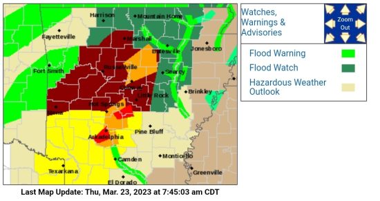
The National Weather Wervice has issued a Tornado Watch in effect until 7 pm Friday, March 24th for the following 10 counties:
In Central Arkansas
Garland Grant Saline
In Southwest Arkansas
Clark Dallas Hot Spring Ouachita Pike
In Western Arkansas
Montgomery Polk
This includes the cities of Arkadelphia, Benton, Bryant, Camden, Fordyce, Glenwood, Hot Springs, Malvern, Mena, Mount Ida, Murfreesboro, Norman, and Sheridan.
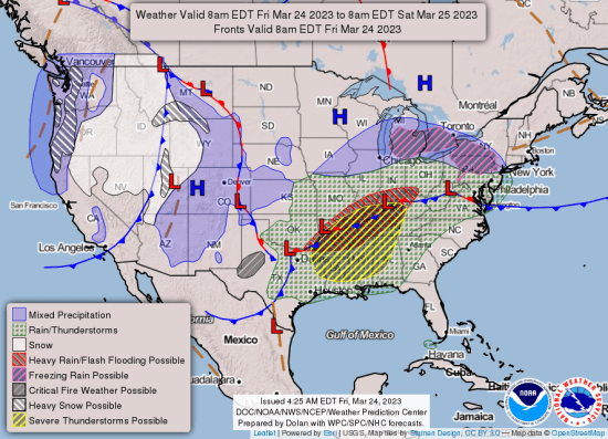
Showers and thunderstorms will become widespread today as a cold front pushes through the area. There is an increase threat for severe storms this afternoon and evening as the cold front pushes through the state. The southeastern half of the state currently sees the greatest risk for hail…damaging winds…and tornadoes. Additionally, flash flooding will be possible across portions of the state given already saturated soils and heavy rainfall expected.
There’s also a Flood Watch in effect through Saturday morning.
What… flooding caused by excessive rainfall is possible.
Where… portions of central, eastern, and western Arkansas.
When… through Saturday morning.
Impacts… excessive runoff may result in flooding of rivers, creeks, streams, and other low-lying and flood-prone locations.
Additional details. rain and thunderstorms are expected to produce widespread rainfall amounts between two to four inches with locally higher amounts possible.
7-DAY FORECAST:


