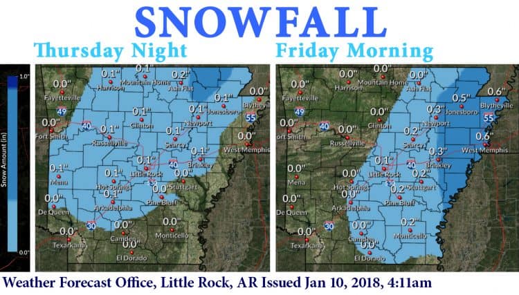
The National Weather Service in Little Rock has issued the following weather briefing:
A storm system continues to approach the state from the west and will bring a little bit of everything to the area. The good news is not a lot of anything is really expected but rain is likely followed by some light winter weather and then by another surge of cold air
The big picture:
- Widespread rain is expected with the best chances in the Thursday afternoon through Friday morning time frame.
- A brief change over to freezing rain and light snow is possible as much colder air returns. Overall amounts will be minimal.
- Much colder air will return for the weekend.
An intense storm system over the western United States will move to the east Wednesday and early Thursday keeping a very moist air mass in place. As the system approaches, widespread rain will develop. While precipitation may be possible at any time, the best chances will be in the Thursday afternoon and Thursday night time frame. Rainfall amounts will average under an inch.
The associated cold front will move through the region Thursday night with much colder air in its wake. As the colder air moves in, there will be a brief changeover to a wintry mix starting over the west Thursday evening and and finally over the east by Friday morning. It appears the coldest air will not coincide with the best moisture so the impacts are not expected to be significant.
The exception will be over the over the east. The storm is expected to deepen east of the state with wrap-around moisture moving over the east. Snow amounts will likely be higher over the east and northeast but should still average under an inch. Some light accretion of freezing rain is possible with a few hundredths possible, again mainly over the east.
The system will clear the east by noon Friday at the latest but another surge of cold air will settle over the area with temperatures well below normal for the weekend.
You can always get the latest information from us at our webpage at www.weather.gov/LZK


