The National Weather Service in Little Rock has issued this Hazardous Weather Outlook, updated Sunday evening, for a Large Part of Arkansas, including the following counties: Boone-Marion-Baxter-Fulton-Sharp-Randolph-Newton-Searcy-Stone-Izard-Independence-Lawrence-Johnson-Pope-Van Buren-Cleburne-Jackson-Logan-Conway-Faulkner-White-Woodruff-Scott-Yell-Perry-Polk-Montgomery-Garland-Saline-Pulaski-Lonoke-Prairie-Monroe-Pike-Clark-Hot Spring-Grant-Jefferson-Arkansas-Dallas-Cleveland-Lincoln-Desha-Ouachita-Calhoun-Bradley-Drew
Sunday Night
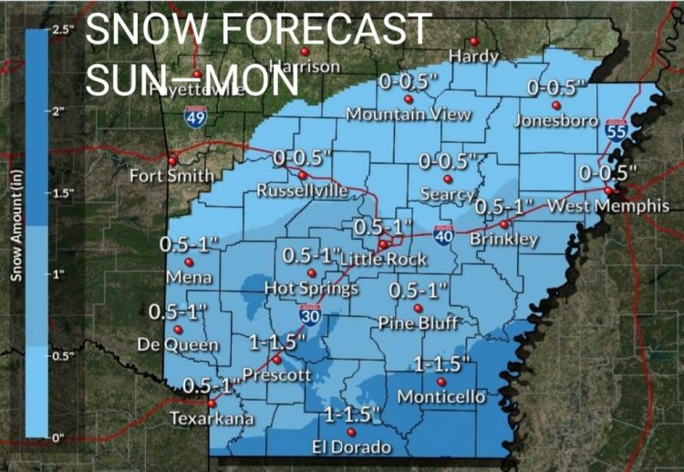
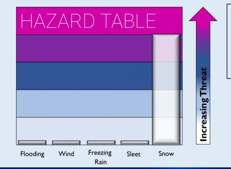
Some accumulating snowfall will be seen across southern sections of the state overnight into Monday morning, with the best chances for seeing accumulating snowfall along and south of a line from Camden to Monticello. These areas may see snowfall amounts of 1 – 2 inches, with locally higher amounts possible closer to the Louisiana-Arkansas border. North of this line, expect less than an inch, with maybe a dusting of snow possible as far north as along a line from Hot Springs, to Little Rock, to Brinkley. Flurries could be seen north of this area, but no accumulations are expected. This snowfall could result in some hazardous travel conditions tonight and Monday morning.
Monday – Saturday
There will be some lingering snowfall Monday morning before the storm system exits to the east by Monday afternoon. While some additional snowfall accumulations are possible, generally less than an inch is expected. There will be an increased threat for hazardous travel conditions during the Monday morning commute.
While the precipitation will have ended by Monday afternoon, there could be some refreezing possible for Monday night as temperature drop below freezing. This may result in some hazardous travel conditions again for Monday night into Tuesday morning.
By Tuesday, expect the threat for additional hazardous weather to become low at this time.
❄️❄️❄️
An update from the National Weather Service in Little Rock from 7 a.m. Sunday stated the previous forecast still appears to be largely on track with only minor tweaks made to timing and amounts over the past 12-24 hours. Southern Arkansas is still favored for seeing the most widespread accumulating snow, with amounts tapering off the farther north you go. See simulated radar maps below for overnight and Monday morning.
Expect snow to begin across southwest into central Arkansas between 6 p.m. Sunday through midnight.
From midnight through about noon Monday, snow will be possible across much of southern Arkansas as well as portions of central and eastern Arkansas. Expect the snow to come to an end by Monday afternoon. See daily forecast below for the next week.
Today
Cloudy, with a high near 38. Northeast wind around 5 mph becoming calm in the afternoon.
Tonight
A slight chance of rain and snow before 9pm, then a chance of snow. Cloudy, with a low around 29. Calm wind becoming north around 5 mph. Chance of precipitation is 40%. New snow accumulation of less than a half inch possible.
Monday
A chance of snow before noon, then a slight chance of rain and snow. Cloudy through mid morning, then gradual clearing, with a high near 42. North wind around 5 mph becoming calm in the afternoon. Chance of precipitation is 30%. New snow accumulation of less than a half inch possible.
Monday Night
Mostly clear, with a low around 24. Calm wind.
Tuesday
Sunny, with a high near 51. Calm wind becoming west around 5 mph in the afternoon.
Tuesday Night
Mostly clear, with a low around 27. West southwest wind around 5 mph.
WednesdaySunny, with a high near 53. Southwest wind 5 to 10 mph.
Wednesday Night
Mostly clear, with a low around 32. Southwest wind around 5 mph.
ThursdayMostly sunny, with a high near 58. Southwest wind 5 to 10 mph.
Thursday Night
Partly cloudy, with a low around 36.
Friday
Sunny, with a high near 51.
Friday NightMostly clear, with a low around 29.
Saturday
Sunny, with a high near 52.


